“I know, nobody knows, where it comes and where it goes.” – Dream On, Aerosmith (1973)
Contour maps provide good, limited info but you just can’t beat walking along the actual creekbed
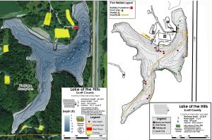
Many lakes like West Lake Park’s Lake of the Hills were created by constructing a dam to impede the flow of an existing stream. The water then pools to fill the surrounding terrain until it reaches the level of an overflow such as a spillway. As the lake fills, the original creekbed is left hidden deep below the surface, gradually collecting sediment over the years. What was once a pronounced channel is often altered as time and nature do what they do.

So how does Blackhawk Creek weave its way through the lakes from west to east? Read on…
Since about 1970, this aging process has been hidden from view on Lake of the Hills. As you can see by the arrows on the map above, Blackhawk Creek runs through the site. It flows from the west entering Blue Grass Lake and eventually exits via the Lake of the Hills spillway, flowing underneath Interstate 280. Until last fall, where it meandered in between those spots was a mystery to those who did not possess either an old plat map or a new-fangled depthfinder.
Clip number one below covers Railroad Lake and the western half of Lake of the Hills
Clip number two covers the eastern half of Lake of the Hills
I found it quite interesting to see Blackhawk Creek and associated tributaries once again flow freely to the outlet valve that formerly lay beneath roughly 16 feet of water. Only a short reprieve, however, as Mother Nature will again be allowed to fill the lake basin once restoration work has been completed.
I’ve said it several times in my video clips but indeed a once in a lifetime experience for this interested angler. A cool glimpse back in time and still more to come from my wanderings. Talk to you later. Troy